Wedi’i ychwanegu at eich Cynllunydd Taith isod
Cyfrifiannell pellter
Hidlwyr Map

Customise your trip with our filters.
Hidlwyr Map
Ewch o un opsiwn i’r llall isod i ddangos y marcwyr sydd ar gael.
Cyffredinol Marchogaeth BeicioLlety
Pwyntiau o ddiddordeb
Gwasanaethau
Llwybrau
Llety
Pwyntiau o ddiddordeb
Trafnidiaeth
Llety
Pwyntiau o ddiddordeb
Trafnidiaeth
Mae'r proffil o uchder eich teithlen yn cael ei greu pan fyddwch yn defnyddio’r cyfrifiannell pellter (uchod) i dynnu llinell.
Mae'r proffil o uchder eich teithlen yn cael ei greu pan fyddwch yn defnyddio’r cyfrifiannell pellter i dynnu llinell.

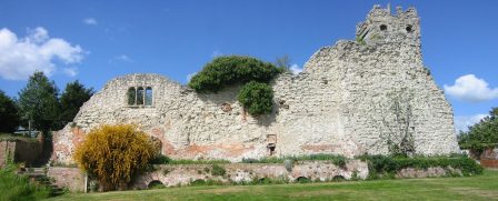
Wallingford Castle was built in the 11th century as a royal stronghold but was captured and demolished at the end of the Civil War. Today, it is possible for visitors to see the remains of St Nicholas College, two sections of castle wall and the motte hill. It is an interesting site to explore and easily accessible from the Ridgeway National Trail (approximately 1 mile away). Parking, shops and services can also be found in the town of Wallingford.