Added to your Itinerary Planner below
Distance calculator
Map Filters

Customise your trip with our filters.
Map Filters
Toggle between the options below to show available markers.
General info Equestrian Info Cycling InfoAccommodation
Points of interest
Services
Routes
Accommodation
Points of interest
Transport
Accommodation
Points of interest
Transport
The custom route elevation is created when you use the distance calculator (above) to draw a line.
The custom route elevation is created when you use the distance calculator to draw a line.

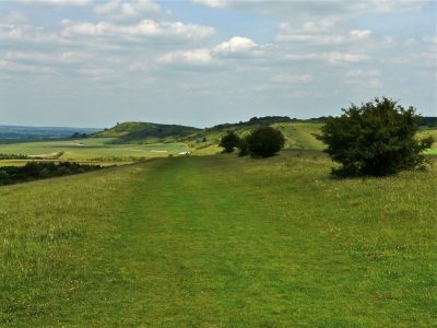
Ivinghoe Beacon is the hill where The Ridgeway begins/ends in the Chilterns. Far-reaching views make the hilltop a popular viewpoint and there are also remains of a hillfort and a trig point.
It is located in an area of scenic countryside of wildflower-rich grasslands and ancient woodlands spread across rolling hills.
Ivinghoe Beacon and the surrounding area is managed by the National Trust as part of their Ashridge Estate. There are several car parks across the area including a large tarmac car park lying south of Ivinghoe Beacon, off Beacon Road. There is a footpath connecting this car park to the Beacon.
Visit the National Trust website for more details.
Discover more about Ivinghoe Beacon through the Ridgeway Top 50 Hillforts, Famous Writers, Icknield Way, Viewpoints and Views, Chalk Figures, Wayfarers and Wanderers, Famous Archaeologists and TV, Film and Music.