Icknield Way
An historic routeway intertwined with The Ridgeway both in the landscape and in people’s imaginations
Popularly known as ‘Britain’s oldest road’, The Ridgeway and Icknield Way are considered by many to be long distance routeways in use since prehistoric times. Visitors are drawn to these routeways to walk or ride in their ancestors’ footsteps or hoofprints. Some say that the Icknield Way extended to the Norfolk coast, and flints from Grimes Graves in Norfolk were carried by traders along the Icknield Way as far as Wiltshire. Modern research suggests such interpretations are more imagination than fact….read on below to find out more.
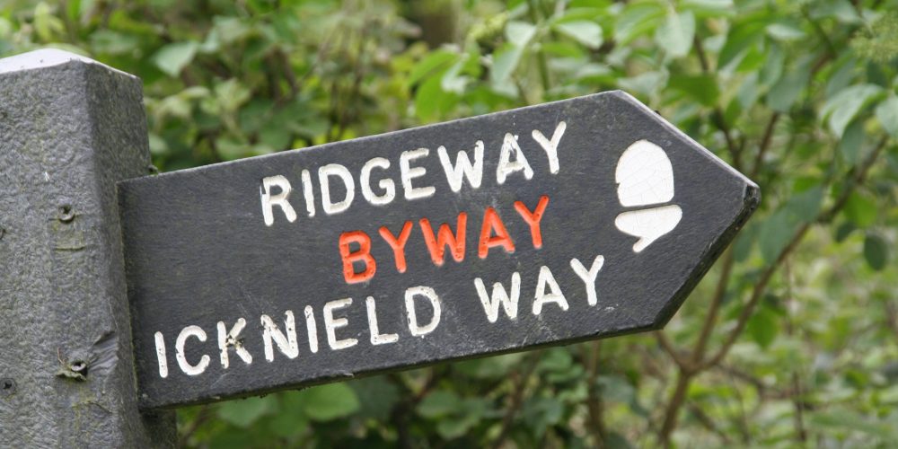


Since 1992, walkers have enjoyed The Icknield Way as a signposted recreational route extending from Ivinghoe Beacon, where The Ridgeway National Trail ends in the Chilterns, to Knettishall Heath in Suffolk. In Suffolk, it meets with the Peddars Way National Trail which continues on to the Norfolk Coast. In 2004, the Icknield Way Trail was opened to provide similar opportunity to cyclists and horse riders. These promoted routes were designed to follow, as much as possible, trackways or the historic ‘corridor’ thought to be the prehistoric Icknield Way.
Promoted routes inspired by historic routeways can create an illusion of certainty or make history seem tangible, but recreational routes are in part a naming or labeling exercise and are also inevitably constrained by the practical requirements of visitors and what remains of historic routeways on the ground. The Ridgeway and Icknield Way certainly follow some routeways that have been used for generations, but exactly how ancient these routes are is debated. Recent research into the Icknield Way by Sarah Harrison, for example, has challenged whether the Icknield Way ever existed as the long distance routeway we have come to believe – is it in fact a product of the ‘creative minds’ of medieval writers?
It was near Watlington, which lies near The Ridgeway as it follows the Lower Icknield Way, that the Watlington Hoard was found in 2006 and this provided grounds for a theory that the hoard of treasure indicated a Viking army used the Icknield Way to retreat from the Saxons into East Anglia. The earliest historic documents mentioning the Icknield Way are in Anglo-Saxon charters dating from 903AD onwards. From west to east, these charters refer to places near The Ridgeway: Wanborough near Swindon, Hardwell near Uffington, Lockinge, Harwell, Blewbury and lastly Risborough in Buckinghamshire.
Later writers developed descriptions of the Icknield Way so that it came to be recognised as one of the ‘Four Highways’ of medieval England alongside Ermine Street, Fosse Way and Watling Street. Maps of the routeway show it taking various courses across the country, passing places as widespread as York, Birmingham and Salisbury. More recent mapping by the Ordnance Survey added to the mix, with O G S Crawford (1886 – 1957) labeling the Icknield Way as pre-Roman alongside the Jurassic Thoroughfare, North Downs Way and South Downs Way.
Crawford also surmised that flints from Grimes Graves in Norfolk were taken along the Icknield Way to be traded as far as Wiltshire, although prehistorians now believe that early trade did not depend on long-distance routes or professional merchants. Instead, items were passed between people time after time and eventually ended up a long way from where they were made. This is known as ‘down-the-line exchange’ and happened especially with unusual or valuable objects.
The ‘sense of history’ that some visitors experience is also a product of the interpretations shared by artists and writers. Most recently, Robert MacFarlane included the Icknield Way in his book ‘The Old Ways’, partly inspired by an earlier writer Edward Thomas (1878 – 1917). Interestingly, the questions raised by modern archaeologists and historians is reflected in a description by Thomas who walked the Icknield Way over 100 years ago in 1911:
‘I know there is nothing beyond the farthest of far ridges except a signpost to unknown places…..I could not find a beginning or an end of the Icknield Way. It is thus a symbol of mortal things with their beginnings and ends always in immortal darkness.’
Labels on modern maps present an illusion of fact and replicate labels from earlier maps. For example, a map today will show the Lower Icknield Way runs parallel with the Upper Icknield Way between Lewknor in Oxfordshire and Ivinghoe in Buckinghamshire. The Ridgeway National Trail follows the restricted byway known as the Lower Icknield Way between Britwell Salome and Hempton Wainhill in Oxfordshire. On the ridge above, the Upper Icknield Way runs parallel as a tarmac road. This is a good illustration of how promoted routes are forced to take the practical route (i.e. avoid the road) rather than the ridgetop route we would expect of ‘The Ridgeway’!
Whatever the prehistoric authenticity of these promoted routes, much of The Ridgeway follows historic routeways with plenty ‘time depth’ to satisfy the average visitor. The popularity of historic routeways will be tested when a new route called ‘The Great Chalk Way‘ is launched to link the Dorset and Norfolk coasts. The route brings together The Ridgeway, Icknield Way and other existing promoted routes into one – that’s a lot of history to absorb!
Notes: More information about Ridgeway writers and wayfarers is available in other Top 50 entries.
The listing you have clicked on is located on or close to more than one trail. Please select the trail you are interested in below to view the listing.
%buttons%