


Added to your Itinerary Planner below
Distance calculator
Map Filters

Customise your trip with our filters.
Map Filters
Toggle between the options below to show available markers.
General info Equestrian Info Cycling InfoAccommodation
Points of interest
Services
Routes
Accommodation
Points of interest
Transport
Accommodation
Points of interest
Transport
The custom route elevation is created when you use the distance calculator (above) to draw a line.
×

The custom route elevation is created when you use the distance calculator to draw a line.
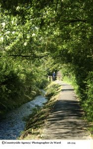
As rich farmland gives way to woodland tracks and rolling parkland, this enchanting walk leads you from scarp top to valley bottom, back into one of the Cotswold’s most charming and thriving small towns. With spectacular views, intriguing shops and historic architecture, all tastes will find something wonderful in this special little corner of the Cotswolds.
- Distance: 5 miles (6½ with detour to Newark Park)
- Duration: 3 - 4 hours (4 - 5 hours with detour)
- Difficulty: Moderate – Stiles and steep sections
- Parking: There are three free car parks
- Public transport: accessible from Stroud, Gloucester via Dursley, Bristol and Yate by bus
- Refreshments: Plenty of places to Eat & Drink in Wotton-under-Edge
Points of Interest:
- The Tolsey Clock (Jubilee Clock)- is attached to the Tolsey building and is one of the feature landmarks of the town. This particular clock has been in place since Queen Victoria’s Diamond Jubilee in 1897, but there has been a clock on the building since 1595.
- Blackquarries Hill Long Barrow - For a slight diversion you can take a detour onto the site of Blackquarries Hill Long Barrow, where there is an information board that shows the history of the site. Known locally as the ‘Clump’ this structure is generally considered to be a long barrow, possibly Neolithic. According to Crawford (Long Barrows of the Cotswolds, 1925) the structure has been considerably mutilated by stone digging leaving only “amorphous remains”.
- Newark Park - a Grade I listed country house of Tudor origins located near the village of Ozleworth, Wotton-under-Edge, Gloucestershire. The house sits in an estate of 700 acres at the southern end of the Cotswold escarpment with views down the Severn Valley to the Severn Estuary.