Added to your Itinerary Planner below
Distance calculator
Map Filters

Customise your trip with our filters.
Map Filters
Toggle between the options below to show available markers.
General info Equestrian Info Cycling InfoAccommodation
Points of interest
Services
Routes
Accommodation
Points of interest
Transport
Accommodation
Points of interest
Transport
The custom route elevation is created when you use the distance calculator (above) to draw a line.
The custom route elevation is created when you use the distance calculator to draw a line.

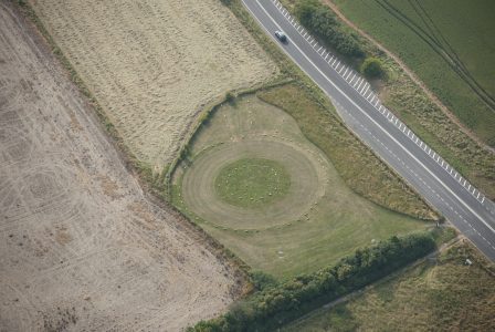
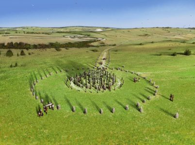
Begun in about 2500 BC, The Sanctuary was originally a complex circular arrangement of timber posts and standing stones. The Sanctuary was once connected to the stone circle at Avebury by an avenue of stones, part of which is now known as 'West Kennett Avenue'.
Today, concrete markers show where the stones and posts once stood.
The site lies adjacent to the A4, opposite the Ridgeway parking area at Overton Hill. There is a permissive footpath from The Sanctuary to West Kennett.
The site is free to visit and open at all times. It is managed by the National Trust on behalf of English Heritage.
Discover more about The Sanctuary through the Ridgeway Top 50 Sarsen Stones, Famous Archaeologists and Druids and Paganism.
Image credits: Historic England.