Added to your Itinerary Planner below
Distance calculator
Map Filters

Customise your trip with our filters.
Map Filters
Toggle between the options below to show available markers.
General info Equestrian Info Cycling InfoAccommodation
Points of interest
Services
Routes
Accommodation
Points of interest
Transport
Accommodation
Points of interest
Transport
The custom route elevation is created when you use the distance calculator (above) to draw a line.
The custom route elevation is created when you use the distance calculator to draw a line.

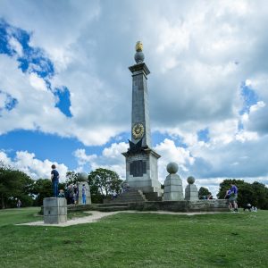
At 852 feet above sea level, Coombe Hill is one of the highest points in the Chiltern Hills and it is topped by an obelisk memorial which can be seen for miles around. With extensive views over the Aylesbury Vale, on a clear day you can also see all the way to the Cotswolds. The hill is rich with native plants, insects and birds and cattle graze the area too.
The hill is managed by the National Trust. It is Open Access Land and the route from Low Scrubs car park to the monument is considered 'easy access' for disabled people and families.
Car parking is available in Wendover at the bottom of the hill or at the top of the hill at the National Trust car park at Low Scrubs (nearest postcode HP17 0UR). Low Scrubs car park gets busy at weekends so arrive early to avoid disappointment or park in Wendover.
Find out more about Coombe Hill through the Ridgeway Top 50 Protests and Progress, Wartime, Viewpoints and Views, Stone Stories, Chalk Flowers, Meeting Places and more.