Thames Path
News from the Trail

News from the Trail
10th – 14th May 2023
This year marks the first ever Reading Walks Festival. Running from the 10th to the 14th of May 2023, the Walks Festival is different from your usual music or food gathering, instead, this festival celebrates what we do on our feet!
With over 40 walks available you don’t need to be a pro-hiker to enjoy this festival, there are walks to suit all tastes, ranging from 1 hour wanders, up to a full 2-day pilgrimage! As you walk, the volunteer guides will share stories of the landscape and heritage of Reading and the surrounding countryside, bringing the landscape around you to life.
The fabulous Thames Path Team are getting involved too, hosting a walk between Reading and Goring along the iconic Thames Path. The walk is around 4 hours, and approximately 16 km, with the option of taking a cruise for the return trip. To join us, or for more information on this walk, please follow this link: Thames Path National Trail Reading to Goring | What’s On Reading (whatsonreading.com)
For information on the entire Reading Walks Festival, please click here: Reading Walks Festival | What’s On Reading (whatsonreading.com)
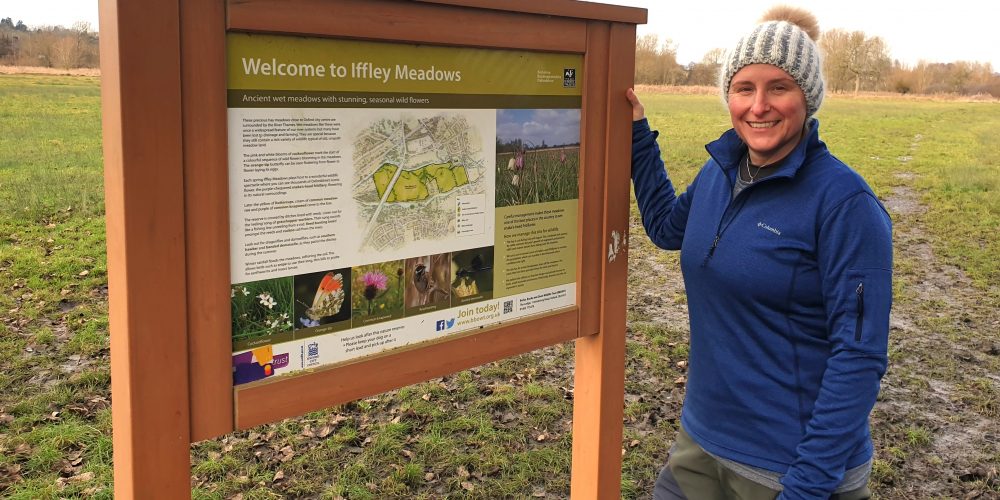
Clare joined the Thames Path National Trail team at the end of January 2023 after a varied history that has seen her working in education, heritage, events and even firefighting!
She brings enthusiasm by the bagful and is looking forward to creating a mixed calendar of exciting Events for the Thames Path National Trail, making it a place where everyone can enjoy spending time. As well as Events, Clare aims to improve awareness of the Trail, and assist the Trail Manager in assuring the upkeep of the path.
Of her new role, Clare says, ‘I am eager to start this new opportunity to increase awareness of the beautiful Thames Path National Trail among local communities in towns, villages and cities that it passes through. There are so many exciting projects to get started on!’
To stay up to date, follow us on Twitter, Facebook and Instagram @thamespathnt to get a flavour of the attractions on the Trail and the River Thames. To contact Clare about Events which take part on the Thames Path, or other comments, email: thames.path@oxfordshire.gov.uk.
Six new projects to encourage and enable more people to enjoy walking on the Thames Path National Trail in London are among the recipients of Active Thames grants announced by the Port of London Authority on 16 January 2023.

The Thames Path may be flooded
Heavy rainfall means the river Thames and its tributaries are on flood alert. The Thames Path may be flooded, do not walk-through floodwater, the current is strong, and the edge of the path hidden under water.
Check local flooding;
Flood alerts and warnings – GOV.UK (check-for-flooding.service.gov.uk)
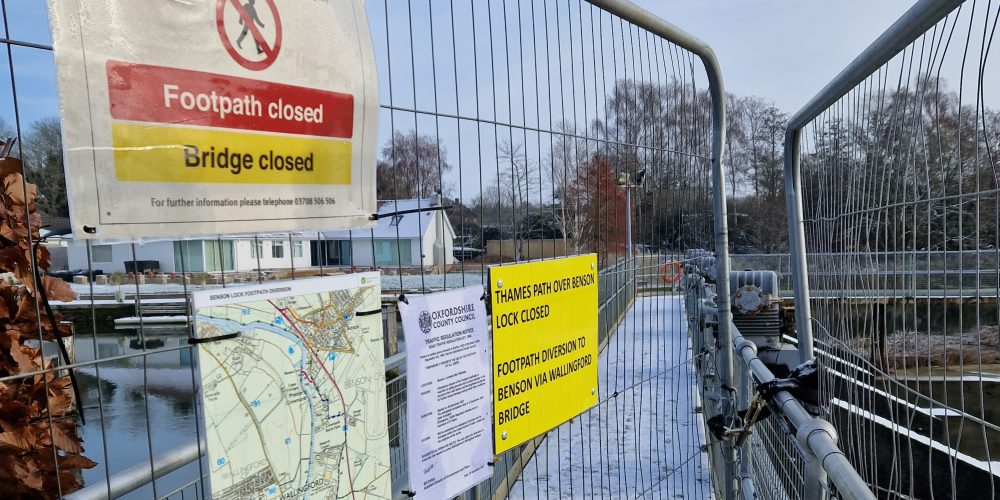
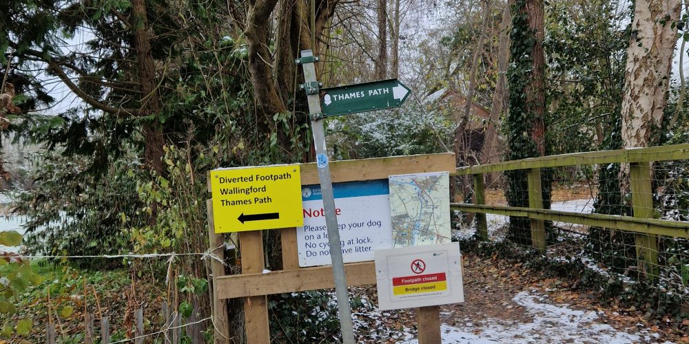
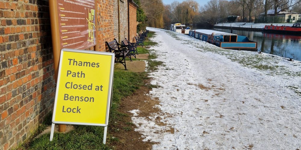
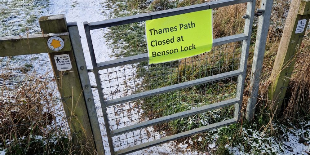
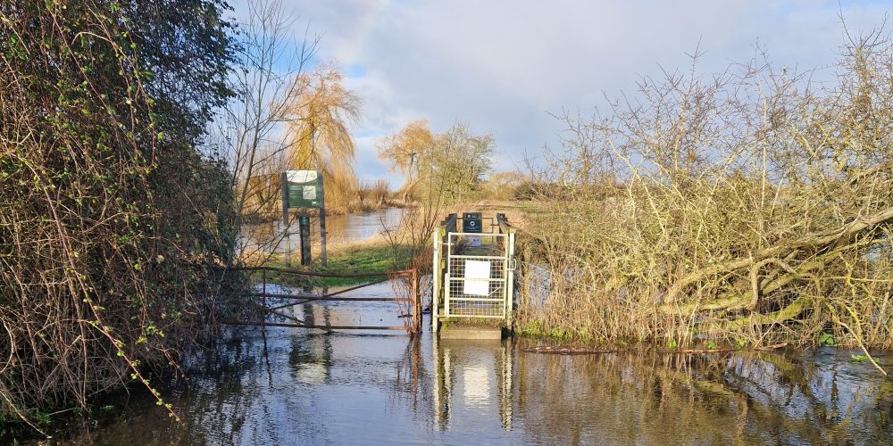
Thames Path diversion in place for the foreseeable future
The EA have closed their walkway across Benson Weir to members of the public due to safety concerns, which they have explained further in their briefing note:
Benson weir walkway closure – external briefing v1 d2
A diversion route is clearly signposted on the ground and we will continue to work with the EA to ensure this important link is reopened.
If you are visiting Wallingford the Path is still open up to the Lock, should you like to enjoy this lovely section of path.


Hurst Park in Surrey
Surface improvements have been carried out by Surrey County Council for a section of the Thames Path in Hurst Park near Walton bridge. The works have improved a well-used section prone to flooding. A natural hard wearing surface material has improved this uneven and often muddy section of path which is particularly popular due to its proximity and access to Hurst Park and the local cafés. The surfacing work was funded by the Elmbridge Community Infrastructure Levy, which Surrey have a successful track history of utilising, to improve the Footpath network in the Borough.
As part of the work some minor revetment was installed using recycled plastic as well as rock rolls, a cost-effective revetment solution which reduces the impact of flooding and high-water levels scouring out the path.
With only a short walk from Hampton Court train station or the free Hurst Meadows car park, you could be checking out the new surfacing for yourself and enjoying the following cafes- Miss Polly Café at the East Molesey Cricket Club, Eight on the River at the Molesey Boat Club and Little H at Molesey Lock.


A review by Wendy Tobitt- Thames Path National Trail volunteer
Open the new edition of the Trailblazer Guide to the Thames Path National Trail at any page and you’re immediately ‘on the trail’.
Beautiful hand-drawn maps and helpful text describe what you can see along the entire 185.2 miles route of the Thames Path following the river from its source to the sea.
The third edition of the Trailblazer Guide is the first guide to the Thames Path that includes the Trail’s extension in London to the Woolwich Foot Tunnel, where it links with the England Coast Path National Trail.
This handy book contains a vast wealth of comprehensive information to help readers plan their Thames Path walk for the full length or a weekend stroll.
The Guide is carefully laid out so it’s easy to read whether you’re walking westwards towards the source, or eastwards towards London. GPS waypoints marked on the maps help keep you on the right track at tricky junctions.
It’s divided into daily stages with start and end points that have public transport and accommodation; but these are only for guidance because everyone walks at different speeds.
Freehand maps by cartographer Nick Hill are particularly useful with annotations such as ‘can be very muddy needing a wide detour’ and ‘follow waymarks through woods’.
The suggested itineraries and maps are written by walkers for walkers, and it’s their entertaining style that makes the Guide so enjoyable to read, with fascinating nuggets of Thames-side history, culture and sport.
Many Thames Path National Trail walkers recommend previous editions of the Trailblazer Guide. This third edition maintains the high standards of accurate information with superb maps; it is a thoroughly enjoyable companion to the Trail.
Full version of this article is published in Thames Guardian, the magazine of the River Thames Society https://www.riverthamessociety.org.uk/
Trailblazer Guide to the Thames Path, 3rd edition with 89 large-scale walking maps and guides to 99 towns and villages. Distributed in the UK by Heartwood Publishing, price £12.99.


The Thames Path National Trail Manager - Feb 2022
Hannah joined the National Trail team at the start of this year after several years working in the public rights of way team with Surrey County Council.
She brings fresh ideas for making the Thames Path a modern trail accessible for all with improved surfaces, good signage and fewer physical restrictions so that people of all abilities can enjoy being by the river.
‘In the first few weeks I’ve met so many passionate people who really care about the Thames Path and the River Thames environment. Everyone is committed to looking after the Thames Path,’ says Hannah.
Hannah is responsible for the management of the 185.2 mile route from its source in the Cotswolds to Woolwich in east London. She works with a Partnership of more than 40 organisations including local authorities, the Ramblers and the River Thames Society to ensure the National Trail is kept in good condition.
‘I can’t help but be motivated by the enthusiasm from community groups championing the Trail, people working in our Partnership organisations, my colleagues and the amazing volunteers in the Thames Path team. I’m looking forward to working with them to develop new projects.’
To contact Hannah with comments and ideas for improving the Thames Path National Trail, email: thames.path@oxfordshire.gov.uk
Follow us on social media @thamespathnt to get a flavour of the attractions on the Trail and the River Thames.

Concerns have been expressed about a new fence erected alongside the Thames Path National Trail close to Mapledurham Lock at Purley- Feb 2022
During February a new fence was erected by the landowner alongside the Thames Path National Trail close to Mapledurham Lock at Purley. This coincided with work at Mapledurham Lock by the Environment Agency to replace the old fish pass and create a new fish pass channel which necessitated a new footbridge over the channel and gates at both ends of the bridge.
We are aware of the concerns expressed by local people that the width of the riverside path has been reduced, consequently it may become muddy and slippery in wet weather. We have discussed this with West Berkshire Council, the local authority responsible for keeping the Thames Path in good and safe condition in the section between Streatley and west Reading. The landowner is also aware of the issues.
We will continue to monitor this, and work with West Berkshire Council and the landowner to improve the situation so that people can walk and run on the National Trail safely.
Storm Eunice will make walking conditions on Thames Path National Trail extremely challenging. There is a high risk of trees and branches falling in high winds.

After the storm has passed you may find fallen trees and branches blocking the Path. Please report these so that we can arrange with our local highway authority partners for them to be cleared as soon as possible. Use Thames.Path@Oxfordshire.gov.uk or Fix My Street if you know the nearby UK postcode, or street name and area.
These new signs on the Thames Path National Trail at Whitchurch Hill mark the Hartley Steps, probably the steepest section of the Trail.

The Hartley Steps signs celebrate the efforts of local resident Eric Hartley who encouraged Oxfordshire County Council to get the much-needed 71 steps installed with a ramp alongside. This makes the steep ascent/descent much safer for cyclists, walkers and horse riders.
This section of the bridleway between Whitchurch Hill and Hartslock is on the chalk of the Chiltern Hills. Contractors who installed the Hartley Steps a few years ago used specialist equipment to drill into the exceptionally hard chalk.
Pictured at the installation of the Hartley Steps signs are volunteers Araba McMillan and Roger Pope, who found a spot of earth soft enough to hammer in the post!
Eric Hartley from the nearby village of Whitchurch on Thames is a lifelong advocate of walks in this area. Over the years he’s walked more than 22,000 miles to research 12 walks, which are published in a book and online on the village website.

Thank you to Eric and Whitchurch Parish Council for your continuing support of the Thames Path National Trail, and thank you to the volunteers who made the Hartley Steps signs in our workshop and installed them.
As from 12th January 2022 the Thames Path National Trail has grown by 1.2 miles!

The Thames Path has now been extended to the Woolwich Foot Tunnel, a distance of 1.2miles (1.95 km) where it meets the England Coast Path which comes inland from Kent to the Woolwich Foot Tunnel. The start/finish of the Thames Path National Trail was the Thames Barrier.
In total the Thames Path National Trail is now 185.2miles (298 km) from the source of the River Thames to Woolwich.
From Woolwich to the Isle of Grain, 47 miles (76 kms), the new National Trail route called the Thames Path, part of the England Coast Path. The Source to Sea distance, following the south bank of the Thames through London, is 232.2 miles (373.7 kms). The length of National Trail along the Thames has been increased by 48.3 miles / 77.8 km)
There are new signs to be made!
Today the England Coast Path is officially open from Grain to Woolwich.
 It connects with the Thames Path National Trail to create a continuous ‘source to sea’ National Trail along the length of the River Thames from the Cotswolds to the North Sea. The entire ‘source to sea’ trail is 232 miles (374 km) following the south bank of the River Thames in London.
The Thames Path National Trail links with the England Coast Path at the Woolwich Foot Tunnel, 1.2 miles east of the Thames Barrier. The Woolwich Foot Tunnel is already an iconic location on the Capital Ring, one of London’s long-distance trails.
We will update the Thames Path website in the next few weeks. Read Natural England’s press release NE ECP Grain to Woolwich PR
It’s lovely to be planting trees instead of cutting them back’ says Thames Path volunteer Ian, pictured with colleague Diana wielding a shillelagh mallet to knock in a stake.
 Earlier this month a dozen Thames Path volunteers planted 170 trees, under the supervision of Tim and Beth from the Earth Trust, to help create a new wet woodland near the River Thames in Oxfordshire.
This is part of the Earth Trust’s River of Life II project on three sites beside the Thames Path National Trail between Clifton Hampden and Dorchester. The new wetland landscape includes 16 ponds, seven backwater channels and 1.6 hectares of woodland.
The trees planted on Church Farm, Little Wittenham include black poplar, alder, several species of willow, oak, holly, buckthorn, common dogwood and blackthorn. Some will grow quickly and others more slowly. This rich variety of species will ensure the biodiversity of the site benefits as soon as the trees planted this winter unfurl their leaves next spring.
Watch this video with aerial images of the River of Life II project
Click on this link for further information.


One of the muddiest sections of the Thames Path National Trail is now much easier to walk along, thanks to this smart new boardwalk.
Upstream from Abingdon the Path goes through woodland, which is often flooded in winter and rarely dries out in the summer.
The new boardwalk made from recycled materials by Hahn Plastics Ltd gives good grip and a sturdy walking surface across the worst of the mud.
Steve Tabbitt, Thames Path National Trail officer welcomes the new weather-resistant surface. ‘This section of the Path is low-lying and has been a problem for years, especially after the last few winter floods.
‘The Thames Path is very popular in Abingdon because it links with circular walks around Radley and makes a very pleasant route into Oxford. I’m delighted that we’ve been able to get this job completed so that people will have easier walks this winter.’
This work has been jointly funded by a grant of £7,000 from the Trust for Oxfordshire’s Environment (TOE) Local Environment Fund, a contribution from Oxfordshire County Council, and funds received by the Thames Path National Trail.

The Thames Path National Trail, the 184-mile long-distance footpath from the source of the River Thames in Trewsbury Mead, Gloucestershire to the Thames Barrier in Woolwich, London, is celebrating its 25th anniversary on Saturday 24 July

The Thames Path was named as one of the country’s long distance recreational routes in the National Parks and Access to the Countryside Act of 1949.
From 1973 the Ramblers and the River Thames Society worked together with local campaign groups negotiating with landowners and local authorities, and lobbying politicians to restore the old towing path from the days of barges on the River Thames.
The final section was opened and the Thames Path National Trail inaugurated at the Thames Barrier on 24 July 1996.
Since then, the Trail has been walked by millions of people and is frequently used for long-distance running and charity events.
In 2012 it featured in the opening sequence of the London 2012 Olympics, which inspired at least one walker to step out on the Trail and experience the variety of countryside and city landscapes.
Steve Good, chair of the Thames Path National Trail Partnership says: “The Trail is one of the most-loved long-distance routes in the country. Some people use it every day to get to work, and it’s a life-time’s goal for others to walk the entire length.
“I hope everyone who loves the Trail will share their favourite sections and places on social media, and inspire even more people to take their next steps along the Thames Path.”
Thames Path walkers are encouraged to share their favourite sections and places on the Thames Path via social media using #ThamesPath25 on Twitter, Facebook and Instagram.
Pictured at Marsh Lock on the River Thames near Henley are representatives of the organisations that set up the Thames Path National Trail.
From the left: Peter Finch chairman of the River Thames Society, Kate Ashbrook Vice President of the Ramblers and general secretary of Open Spaces Society, Des Garrahan former chair of the Ramblers and founder of Metropolitan Ramblers, Steve Tabbitt and Elaine Townson, Thames Path National Trail team.
Photo: Wendy Tobitt, Thames Path National Trail volunteer wendy.tobitt@btinternet.com
Thames Path National Trail social media:
![]()
![]()

Due to high rainfall over the past few weeks the upper reaches of the Thames and the Trail from Ashton Keynes to Cricklade may have localised flooding.

In the upper reaches – including Water Eaton, Castle Eaton and Cricklade (thanks for photo above taken by ‘Walk the Thames’ ) – prepare to come across some flooding and muddy sections. Do NOT attempt to walk through floodwater.
The Waterhay car park (called Waterhay for a reason) is very susceptible to flooding. Most of the year this makes a very accessible car park and picnic spot, with footpaths through to Ashton Keynes, North Meadow National Nature Reserve and Cricklade.
Location: Along the Ashton Keynes to Cricklade Road, next to the bridge across the River Thames.
Waterhay, Leigh, Swindon SN6 6QY, UK
May 26th 2021
Keep your walking boots waterproofed for the next few weeks! Some parts of the Thames Path in the countryside are still wet although there hasn’t been any rain for days.
It’s been a wet winter with heavy rainfall from the autumn through to March, especially in the wide catchment area of the upper reaches of the Thames above Reading. This catchment area includes all the tributary rivers and streams that feed into the River Thames. Several of these rivers and the Thames itself flooded for weeks onto land that was already wet.
Fields and meadows beside the River Thames were saturated with water from rainfall before the river flooded onto them. Soil absorbs as much water as it can and then water sits on top, making a squelchy wet surface for walking, and it can take some time for the surface to dry out.
The aquifer that feeds the spring at the source of the River Thames, in Trewsbury Mead near the village of Coate in Gloucestershire, has been flowing well throughout the winter. This aquifer often dries out in the summer, but groundwater levels are likely to remain high this spring say hydrologists at the British Geological Survey in Wallingford. Their UK Hydrological Outlook forecasts river flows in south east England are likely to be normal to above normal in March. More information: http://hydoutuk.net/latest-outlook
Before you set out
• check the Flood warnings web page
• check the River Levels
• check if there are diversions you could make, in case you encounter very muddy or flooded routes
River levels are still high along parts of the River Thames. Flooding of the Trail and low lying roads and land is possible.
Walkers are advised never to attempt to walk through floodwater as it is not possible to see where the river bank starts.
Up-to-date information on Flooding

Throughout this season prepare to come across some flooding and muddy sections
Before you set out
• check the Flood warnings web page
• check the River Levels
• check if there are diversions you could make, in case you encounter very muddy or flooded routes
River levels are still high along parts of the River Thames. Flooding of the Trail and low lying roads and land is possible.
Walkers are advised never to attempt to walk through floodwater as it is not possible to see where the river bank starts.
Up-to-date information on Flooding
Due to increased footfall along the Trail there may be areas of churned up mud especially around gates or where cattle have gathered.
Throughout the year repairs are required to the Trail. There are erosion issues as the riverbank is worn by the Thames, or surfaces needing to be replaced after they have worn and become difficult for Trail walkers. See the gallery for photos of Trail repairs at Radley, Benson and Streatley undertaken through summer 2020.


Thames Path and Ridgeway National Trails volunteers, a group of volunteers hosted by Oxfordshire County Council, have been honoured with the Queen’s Award for Voluntary Service, the highest award a voluntary group can receive in the UK.

The National Trail Volunteers help to maintain, enhance and promote the 2 Trails. The Thames Path starts at the source of the Thames, near Kemble Gloucestershire and follows the river 184 miles to the Thames Barrier Greenwich. The Ridgeway runs for 87miles from Overton Hill near Avebury to Ivinghoe Beacon in Buckinghamshire.
The volunteers keep the public informed and engaged through social media, help in the office, monitor sections of the Trails reporting back any issues, through to working in all weathers maintaining our National Trail standards. Every week throughout the year volunteer work parties install signs, repair gates, cut grass and clear scrub, to name but a few tasks. Volunteers come from towns and villages along the trails, and further afield.
Everyone has a passion to help keep the trails open for the local communities as well as national and international tourists, which in turn helps attract more visitors to the many pubs, cafes and tourist destinations the Trails have to offer.
The Queen’s Award for Voluntary Service aims to recognise outstanding work by volunteer groups to benefit their local communities. It was created in 2002 to celebrate the Queen’s Golden Jubilee. Recipients are announced each year on 2nd June, the anniversary of the Queen’s Coronation. Award winners this year are wonderfully diverse. They include volunteer groups from across the UK, including a community shop in Cornwall, a group working with refugees and vulnerable people in Stirling and our very own National Trail Volunteers.
Chairman of the Thames Path National Trail’s Partnership and volunteer, West Oxfordshire Councillor Stephen Good said: ‘I’m delighted that our group’s work has been recognised, it pays tribute to all the hard work and commitment from our volunteers’.
Representatives of the National Trails will receive the award from Tim Stevenson OBE., Lord Lieutenant of Oxfordshire later this summer. Furthermore, two volunteers will attend a garden party at Buckingham Palace in May 2021, along with other recipients of this year Award.
Dr Mayon-White, a National Trails Volunteer, said:
‘We’re out in all weathers looking after the Thames and Ridgeway because we love the countryside and enjoy making these National Trails easier for everyone to enjoy them. It’s a great honour to be recognised with the Queen’s Award, for doing something that we enjoy so much and is valued by everyone using the Trails. Many of us are in our retirement years, but that doesn’t stop us from taking on tasks such as online mapping and social media, making and putting in fingerposts and installing gates.’
Marian Spain, Natural England’s Chief Executive and a regular user of The Ridgeway, said: ‘I am delighted to see this prestigious award go to the dedicated volunteers on the Thames Path and Ridgeway. Not only do they play a significant role in maintaining the quality of the trail, but the volunteer group also provides many people with an opportunity to connect with nature whilst walking on the paths. Living close to The Ridgeway I can vouch for just how well cared for this Trail is and how valued it is by locals and visitors alike.’
Visit The Queens’s Award for further details.
To learn more about the Thames Path and Ridgeway National Trails and volunteering opportunities visit https://www.nationaltrail.co.uk/ and click on the links to find each of the Trails.
Follow us : @ThamesPathNT

We hope you will enjoy walking the Thames Path, so please follow the Government guidance given on our main page https://www.nationaltrail.co.uk/en_GB/trails/thames-path/
Also when you’re out and about, do remember the Countryside Code
Follow @ThamesPathNT on Twitter and Facebook for news from the Trail, and share your photos and stories.
Only travel to the Thames Path if you haven’t got suitable places to enjoy closer to home. Usually we would welcome lots of visitors, but social distancing reduces the numbers of people that car parks and the Trail can accommodate.
The Thames Path National Trail is very narrow in many places, even in towns, which makes it difficult for people to stay safely 2m apart from others.
If you’re walking, running or cycling (where permitted) on the Thames Path, please be considerate of other users and take the required action to maintain 2m distance from people as you pass each other.
Do not congregate around gates and areas where boats are moored. Please be respectful of boat users. If you’re on a towpath or beside moorings then you’re probably within 2m of the people living on the boats.
The Canal and River Trust has issued useful advice for boaters and people using towpaths,
Here’s advice from London’s Parks and Green Spaces
Consider waiting to visit popular beauty spots until after restrictions have eased. Be considerate of local residents and farmers, they’re also having to keep to government guidelines.
We’ve had to put on hold the Thames Path National Trail volunteer scheme. This means that our volunteers are not able to monitor all 184 miles of the Trail to report on safety issues including obstructions, erosion, damaged signs, fallen trees.
If you spot anything that would be a risk to the safety of people using the Path, please report the location, giving OS coordinates if possible, to Thames.Path@oxfordshire.gov.uk and we will do our best to work with partner Highway Authorities, the Environment Agency and landowners to resolve the problem.
We and our contractors are catching up with mowing and managing the riverside vegetation, so please take extra care if you meet people working on the Path, thank you.
The Thames Path National Trail will still be here for you to enjoy after the current Covid-19 restrictions are lifted.
Stay apart – Act responsibly – Save lives
Follow @ThamesPathNT on Twitter and Facebook for news from the Trail, and share your photos and stories.