


Added to your Itinerary Planner below
Distance calculator
Map Filters

Customise your trip with our filters.
Map Filters
Toggle between the options below to show available markers.
General info Equestrian Info Cycling InfoAccommodation
Points of interest
Services
Routes
Accommodation
Points of interest
Transport
Accommodation
Points of interest
Transport
The custom route elevation is created when you use the distance calculator (above) to draw a line.
The custom route elevation is created when you use the distance calculator to draw a line.

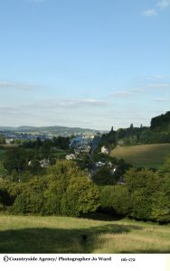
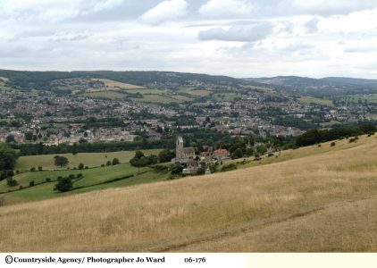
This extremely popular walk is one of the easiest to follow, winding its way along the National Trail for nearly all of its length. From sheltered beech woodlands and over rich open grassland, it guides you around remnants of an industrial past that shaped the landscape we love today. Wander between the grandeur of Victorian mills alongside the sleepy beauty of the waterway, and discover a timeless journey between past and present that reveals yet another face of the glorious Cotswolds.
- Distance: 5 miles
- Duration: 3 - 4 hours
- Difficulty: Moderate - Three stiles, some steep sections
- Parking: Kings Stanley Village Hall
- Public transport: accessibly by bus from Stroud and Gloucester or train from Stonehouse
- Refeshments: The Bell Inn Selsey, The Boho Bakery (Cafe) Kings Langley, Kings Head Kings Langley
Points of Interest:
- Selsey Common - is a sizeable area of limestone grassland, on a flat-topped spur along the edge of the Cotswold escarpment; to the west the land drops steeply by over 300 feet, and most has far-reaching westwards views, across the Severn Valley towards the Black Mountains in Wales. The common is still used by local residents for livestock grazing, in accordance with ancient rights. Besides the views, the other main attraction is the variety of the calcareous grassland wildflowers, and in recognition of this, together with some interesting geology, as evidenced by several rock faces from ancient limestone quarries, the common is designated as a Site of Special Scientific Interest (SSSI). At least eight orchids are found here; bee, common spotted, common twayblade, early purple, fly, fragrant, green-winged and pyramidal, together with many other species.
- All Saints Church - the only church in Britain to have all its windows designed by Morris and his colleagues.
- Ebley Mill - Once the largest cloth mill in Stroud valley, and for many years owned by the Marling family, Ebley Mill won design awards when it was converted into offices by Stroud District Council in 1989.
- Stroud Water Canal - This was the first canal built and joined Stroud to the River Severn just beyond Saul Junction. It was opened in 1779. Called the Stroudwater Navigation it enabled Trows to carry goods from Stroud to ports on the River Severn. With the later building of the Gloucester Sharpness canal the two were joined together at Saul Junction. The waterway climbed up from the Severn Plain into Stroud. The Stroudwater was initially commercially successful but profits were badly hit by competition from the railways, and was eventually abandoned in 1954. Much of the line of the canal is intact and many distinctive features and buildings remain.
Optional route for Walkers:
Walkers following the Circular Walk from King’s Stanley across Selsley Common and the walk downhill to the pedestrian controlled crossing over the A419. This was formerly a railway line known for the “Dudbridge Donkey”. Then walkers turn westwards along the tarmac cycle track through the community orchard towards Ryeford.
After 0.3 miles along this cycle track there is now a choice. Continue along the tarmac route to Ryeford or look for a metal kissing gate on the right to take you across a water meadow to the canal towpath. The towpath is reached by following the green waymarking discs through some new houses to a waymark post on the towpath.
If you wish, it is interesting to turn right to walk to Ebley Mill. However, if short of time, turn left and follow the canal westward, passing the double locks, and re-joining the original Cotswold Way on the bridge at Ryeford Road. Here, a signpost directs walkers south to King’s Stanley or north to Painswick.