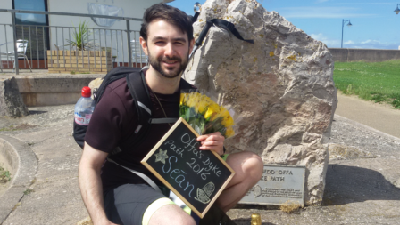
177 Miles Offa's Dyke Hike for Charity Complete!I completed the path on July 10th 2016. Just a few days before my brothers wedding and before I moved over to America to get married. What started as a hike for Cancer Research UK ended up being a fantastic chance to say goodbye to the countryside I grew up in.It was certainly a great experience taking me a year in 12 stages hiking the Offa's Dyke Path stretching across length of Wales, 177 miles from Sedbury Cliffs to Prestatyn Beach (+ how ever many miles I added when I got lost). I've saw many fields, sheep and churches. Trampled over stone, through forest and mud. The weather wasn't always kind, but the views were always spectacular.Thanks to Cailin (My now wife), Benjamin Connell and Paul Connell for joining me for a stage each. Special thanks my mother Michele who helped facilitate my transport, and did a lot of driving and waiting around. Thanks to National Trails and Offa's Dyke Path for taking care of this amazing route, and helping me not get lost as much as I might have.Finally I am extremely grateful for everyone who donated and should say you can still do so by going to: www.justgiving.com/SCOD-2015Below I have written about my gear below and given a casual summary of each stage as a record and on the off chance it helps anyone. Obviously there is much much more that I haven't mentioned, but for that you'll have to walk the Offa's Dyke Path yourselves and find out€¦ Good luck and happy walking!Equipment:- Merrell Men's Moab Mid GORE-TEX Boots with Vibranium soles €“ You always build a relationship with boots and these I love. To be honest they are not as waterproof as you need for walking in this environment (even with weathering spray) but they are comfortable, supportive and flexible.- 20L Berghaus Day Pack (was adequate although the zip straps broke almost straight away and the plastic chest clip gave out as well eventually. It was mildly water resistant and comfortable however.)- Socks. I started with a few pairs of GoOutdoors own brand double lined multi season socks. They weren't high quality and the lining ripped pretty quickly. I replaced them with 1000Mile 2 season Approach socks also with an inner sock lining and they are great, no troubles. I was worried about blisters but this double inner lining stuff is a god send.- Multiple walking poles, I opted for cork hadles and started with the cheapest ones from GoOutdoors. I went through multiples of these since the springs gave out or I fell over and bent them in a stile. I ended up with a pair of Mountain kings, they were a little more but still reasonable. Rubber handles but seemed to be better made. Hand strap not as comfortable however)- I also carried with me winter running gloves to keep my hands warm- Although the service from GoOutdoors was terrible, they have a pretty great deal for getting equipment. If you can find the equipment online on a real company site for cheaper they will match the price and then take 10% off. I did this and got my boots for almost 50% of the price.- If I was to do this hike again I'd equip my self with more wet weather gear including boots built for wet weather and gaiters, since even on dry days the dew on wet long grass just drentched my socks. My map pouch was not at all waterproof either and on one occasion turned my map pages to pulp. My pack and breathable running rain mack held up well, but could do better on the worst days.Maps:-Trailblazer's Offa's Dyke Path 4th edition.It's a nice little read and its his day stages I followed. It has hand drawn maps you use to navigate the path. Which although quaint are not always the easiest to interpret. You may begin to realise why I get occasionally lost, even if they do make the whole expedition a great deal more Hobbit'ish. The book maps from north to south so I had to use the maps in reveres. To make things simpler and lighter I photocopied the maps for each section to just carry in my less that waterproof map case.-I also had some ES maps for the more weather inclined rougher sections but I didn't really use them and the one time I did it wasn't scaled close enough to help.- At times I tried to use the map on my phone or google farm names to see where I was, it helped but most of the time was very frustrating because obviously virtually no signal on the Dyke.- Would recommend tracking your route with GPS if you have one.For anyone wondering, here is what I packed in my 20L Berghaus Day Pack:- 2x 750ml water bottles- Lanyard with Mini torch + house key + Whistle attached to the bag.- Travel charger* + matches + dry paper in waterproof bag.- Multi tool*- Microfibre towel- OS Map*- Easily reachable protein bar + tissues- Phone charger*- Map case: trailblazer maps + pen + national trails path log- First aid kit- Mini sun screen- Travel walletFood Bag- Energy gel*- Salted nuts*- Chocolate bar- Oats breakfast bar*- 2nd protein bar- Apple- Biltong*- Packed meal, usually Tuna + Pasta meal- ForkClothes Bag (plastic to keep out water)- Spare socks- Breathable rain jacket- Highly visible spare shirt*- Long sleeve shirt*- Shoelaces- Hat (either cap or winter hat, depending on conditions)*Things I removed for weight purposes after a few hikes of not needing themDay 1 €“ Sedbury Cliffs to Monmouth -Took just under 10 hours-Only got properly lost twice-Going up hill sucks.-Listened to (and finished) World War Z the unabridged audiobook-Shoes held up pretty well, feet are not all that bad, considering.-Wasps love jerky.-When going through that much physical exertion for that long you literally go though every emotion at some point.-Going downhill sucks.-1 cancer research tshirt acquired-1 news paper article about my walk published-Woods are boring compared to fields-When you haven't seen anything or anyone in a few hours you get surprisingly happy to see cows & sheep, a river, a trail signpost...pretty much anything really.-I'm a walking pole convertAmazing first day, only 156.5 Miles to go! (probably a little more if I get lost)Day 2 - Monmouth to Pandy- 19 miles in 7 hours 30 Minutes- Only got lost once...almost immediately after I started- Lots more livestock, including being chased out of one field by a large defensive horned mother cow.- I've never appreciated quite how rolling our countryside is. Up and down again and again.- Feet noticeably more angry this time- Sunburn restricted to my left forearmDay 3 - Pandy to Hay-On-Wye - 17.5 miles in 6 hours- Highest point: 703m/2306ft over the Black Mountains- Lots of up...mainly up- A little bit of down too- Lots of sheep- Lots of wild ponies- LOTS of poop from both- Must admit the novelty is wearing off a bit- Tied my boot too tight and this had me suffering about 10 miles in- Increased pace due to unwillingness to be over taken by other hikers- 55 miles down, 122 miles to goDay 4 - Hay-On-Wye to Kington - 14.5 miles/23.5 km in 6 hours- Cold and foggy to start, warmed up a lot later.- Bogs and mud.- Rolling hills.- Feet swelled to make me 9% more hobbit.- Really tough to get into this one, neither body nor mind cooperating.- Naked Lunch by William S. Burroughs perhaps not the most appropriate audiobook to listen to while hiking.- Ate some wild Raspberries!- 69.5 miles down, 107.5 miles to goDay 5 €“ Kington to Knighton with Cailin- 13.5 miles/22 km in 6 hours- Cold winds, rain, hail€¦oh look a bit of sun...cold wind & rain again.- Sheep€¦all the sheep- Sheep poop, sheep poop, sheep poop- Never quite managing to find the correct exit gate from the field but stumbling onto the path anyway- Virtually no humans at all and no other hikers on the trail today- Stumbled upon (and almost stepped on) the good people at National Trails with Powys Countryside Volunteers building a lovely new set of steps, thanks for the hard work!- This section of the path is very well maintained- Managed to make it just before the Offas Dyke Centre Closed and purchased a few little tokens- 83 miles down, 94 miles to goDay 6 - Knighton to Brompton Crossroads- 14.5 miles/22 km in 7 hours 45 minutes- Mainly over cast with a few hours of sun...I now have pink arms.- Only got mildly lost once.- This is reportedly the hardest section of the dyke and at the first elevation you realise they aren't kidding.- Should have eaten more carbs for breakfast.- Nothing as soul wrenching than coming down a steep valley seeing the path clearly going directly up on the opposite side and realising your fate.- This part of the route is akin to walking 14 miles on ruff ground and doing 200 squats every 30 minutes.- So much Dyke, Lots of Dyke, oodles of Dyke,- Sweat dripping from my hair, water bottles empty, there is a tap in a box in a field about mid way, would encourage people to top up, even if the prospect of carrying more water up the hill is rather daunting.- Totally exhausted- 97.5 miles down, 79.5 miles to goDay 7 - Brompton Crossroads to Buttington with Ben- 12.5 Miles/20Km in 5 hours 30 minutes- How hot? bloody hot!- Lots a flat lands to start off- Some hilly bits a bit later on, which after last weeks section feel like a personal insult- Benjamin seemed to be enjoying having a good hike even if he was a bit grumpy about the hills- Stiles with dog flaps, well, I, never.- Oh look a donkey- Still very hot- 110 miles down, 67 miles to goDay 8 - Buttington to Nant-Mawr- 14.5 Miles/23.5Km in 4 hours 35 minutes- Starting the day and one of my walking sticks is broken, only one for today then.- 20 minutes later the chest strap on my bag breaks.- All this puts me in a bad mood and I march off to get it over with.- Embankment walking gets sort of tedious, not my favourite.- Lots of walkers on the dyke today.- Curious little notes left on some of the gates like "Group 1, 9:48, We are good thanks xxxx"- A table where you can buy delicious cakes on the path, yes please!- Lots of angry looking cows.- Attacked by one swan.- My maps seem to use Chinese takeaways as reference points unusually often.- Unfortunately the maps decide giving you the canal bridge numbers wouldn't be worth while for some reason, making things harder€¦- Finally got my hands on some Best Offa Beer from Montys Brewery! Some cash from this delightful stuff goes towards National Trails and the dyke. I got two boxes!- 124.5 miles down, 52.5 miles to goDay 9 complete! Nant-Mawr to Irish Bridge- 15.65 miles/25.20 km in 6 hours 34 minutes- Path looking a little over grown this time of year- long field grass and rain means all the water in the world ended up flooding my socks and boots.- Fell over and bent a walking pole- Wet- Rough ground- Wet- 135 miles down, 42 miles to go!Day 10 €“ Irish Bridge to Llandegla- 14.37 miles/23.13km in 7 hours 23 minutes- Only got lost twice€¦may be a little at the end as well- Spent half the night attempting to dry out my boots with a hair-drier- New walking poles purchased- All the different kind of weathers but definitely rain- The most varied terrain on the path so far, forest, fields, canals roads, moorland, hills, slate...- Thank god for National Trails, the walking planks installed over the boggy moorland, how on earth would it be possible without?!- It was the longest day of the year and boy did it feel long.- 147.5 miles down, 29.5 miles to go!Day 11 - Llandegla to Bodfari- 17.5 Miles / 28 Km in 8ish hours.- Rain, wet, damp, soaked, sodden, moist- Oh drat only one headphone- LOTR soundtrack makes the journey surprisingly tense, jumped at cows appearing during and uruk-hai battle theme.- Mist and bad weather chasing me along the hilltops- I always try and pick up a little litter dropped by other hikers on the rout but this section is by far the worst, 5 pocket fulls in total.- a Really well signposted section never needed my map for navigation once, which is good because the rain had destroyed it- On to my second pair of socks by lunch time, using the plastic bag trick to stop my drowned boots from transferring liquid to my dry socks. It works but you have less grip inside the boots and I suspect put more pressure on your ankles- Constantly impressive views- 3 buses of tourists going to the Jubilie tower, couldn't help but begrudge the fact that I had to walk there, hope they had fun though.- A long windy, wet, tough day. Almost done.Day 12 Bodfari to Prestatyn and Finish with Paul- 12 Miles / 19.5 Km with my father Paul in 8ish hours- Hehehe town of Sodom- Managed to get quite lost for a bit- Llamas!- My toes hurt from going down, my ankles hurt from going up- As I knew he would Paul cannot resist stopping to examine the flora and forna.- This section is probably much nicer north to south on your first day, for my last day however I'm just trying to finish- Mum waiting for us by the beach with champagne and flowers, its been a long hike- Paddling a little in the sea feels amazing after such a wonderful hike on the Offa's Dyke Path!